Rhinefield Ornamental Drive
the
Rhinefield Ornamental Drive
Overview
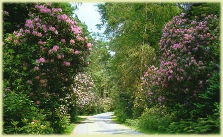
The southern end of Rhinefield Ornamental Drive is the sharp bend at the entrance of Rhinefield House, once a private country mansion but now a hotel. The house was built in the second half of the nineteenth century and boasts a huge garden with ornamental ponds, not to mention the idyllic setting.
There are several walks that start and finish from Rhinefield Ornamental Drive, the most popular being the aptly named Tall Trees Trail.
This is a short walk (about 1 1/2 miles) on a level graded gravel track that runs each side, and parallel to, the road. The walk can be started from (and finished at) either Blackwater or Brock Hill car parks and is the perfect way to experience the height of these trees first hand.
A short stroll from Blackwater car park will get you to the Blackwater Arboretum. This is a relatively small area that contains a selection of trees from around the world. The gravel track around the arboretum includes a number of points that encourage you to touch, smell and listen to the sound of certain trees, while a number of wooden benches provide pleasant resting places to soak up the atmosphere.
At about the time of construction many non-native trees were planted along the track leading to the house; 1859 was the main year that many of the trees seen along the Ornamental Drive today were planted.
Trees that can be seen include giant redwoods and Douglas firs. In fact, the two tallest trees of the New Forest are here, a pair of redwoods standing each side of an open grassy ride. In America, redwoods are known to be up to 3000 years old, so at about 150 years old the two found here are mere youngsters!
Getting To Rhinefield Ornamental Drive
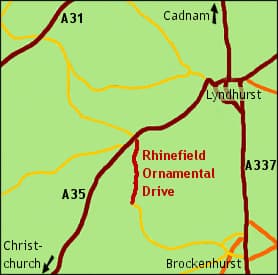
The easiest way of entering the Ornamental Drive is from the A35 road, approximately 2 miles west of Lyndhurst. Turn left at the crossroads of Rhinefield and Bolderwood Ornamental Drives, Brock Hill car park is almost immediately on the right with Blackwater car park further down the Drive on the left.
Alternatively, from the western end of Brockenhurst High Street (Brookely Road), turn right after the water splash and just follow the road until you pass Rhinefield House on the left.
Click image below to explore the Rhinefield area using satellite imagery…
GPS / SatNav information:
Lat/long: 50.841,-1.621. OS grid ref: SU265045
Related pages

A Guide to Trails and Park Terrain
There is a specific smell that hits you the moment you step out of the car in the New Forest. It is a mix of damp oak leaves, ancient soil, and honestly, a little bit

New Forest Activities for Single-Parent Families
The New Forest offers a wealth of year-round experiences perfect for single-parent families looking to create lasting memories. From spring woodland walks surrounded by bluebells to summer picnics by gentle streams, the national park provides

Practical Equipment for Life on the Road
More people choose mobile living every year, from weekend caravanners to full-time digital nomads. Homes on wheels promise freedom, changing scenery, and a lifestyle that breaks away from traditional routines. That lifestyle only feels comfortable

How to Enjoy the New Forest’s Nature and Wildlife Without Breaking the Bank
The New Forest is one of the UK’s most cherished landscapes, a place where ancient woodlands, open heathlands, free-roaming ponies, and peaceful villages come together to create an unforgettable outdoor escape. And while many people

Why Time in Nature Complements Daily Astrological Guidance
Many of us start the morning with a quick look at our horoscope. A few lines can help name our mood, highlight a tension, or point out an opening in the day. What often gets
UK’s best natural spots
Wilderness escapes are not for everyone, that’s for sure. Some people simply prefer holidays where they can lounge all day and take it easy instead of being active, going hiking, swimming, or cycling. But there

