The New Forest National Park location and how to get there
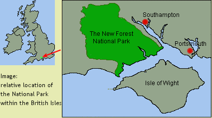
The New Forest National Park location is on the south-central coast of England and lies within the county of Hampshire.
The map below shows the Park location within the British Isles and its approximate boundaries (not to scale). For a more detailed view of the area, please see the New Forest maps page.
If you encounter any difficulty ordering your copy of the e-book please don’t hesitate to contact us via the contact form here
Covering an area of about 220 square miles, the New Forest National Park takes in approximately 15 miles of coast between Calshot Castle (most easterly point) and Hurst Castle (most southerly point), and stretches northwards to Whiteparish and westwards to Ringwood. On the easterly side is Southampton Water, but the National Park boundary falls just short of this.
The main tourist centre is Lyndhurst which lies almost in the geographical centre of the National Park.
The New Forest National Park is bisected by the A31 road which meets the M27 motorway at Cadnam (Junction 1), making access by motor vehicle very simple.
There are several roads heading out into the Forest from the A31, notably at Stoney Cross and Picket Post.
Cadnam is the biggest gateway into the New Forest from the east and is just a few miles from Lyndhurst. From the west, the market town of Ringwood marks the National Park boundary on the A31.
There are three major cities located close to the National Park, these are Bournemouth, Southampton and Portsmouth, the latter being the furthest away to the east. Both Southampton and Bournemouth have their own international airports.
A major railway line runs through the National Park with several stations across the area at (from east to west) Ashurst, Beaulieu Road, Brockenhurst and Sway. The rail journey from London takes about an hour and a half, making a day trip to the heart of the New Forest National Park from the capital very easy (or vice versa, of course!).
Coach travel is a lower cost option with major coach stations or stops in all the larger towns.
More detailed information on the methods of travel outlined above can be found at: